Just around the bend
Florida Trail ‘Big Bend’ reroute approved for implementation
by Shawn Thomas, Florida National Scenic Trail Administrator
Adapted from an article originally published in the Florida Trail Association Footprint magazine
Over 1,100 miles of the Florida Trail (FT) have been successfully certified, highlighting some of the most scenic and diverse natural areas found anywhere in the country. However, more than 300 miles of trail gaps remain in order to complete Florida’s own National Scenic Trail. Over the past several years, the U.S. Forest Service’s Florida National Scenic Trail Program has been working closely with partners from the Florida Fish and Wildlife Conservation Commission, the Suwannee River Water Management District, Florida State Parks and the Office of Greenways and Trails, the Florida Forest Service, Taylor County, Four Rivers Land and Timber Company LLC, the Florida Greenways and Trails Foundation, and the Florida Trail Association to study and propose a solution to one of the largest gaps in the Florida Trail. The U.S. Forest Service (USFS) convened a planning team to look at alternatives within the focus area that included State agencies and the Florida Trail Association (FTA).
A viable public land route for this 50-mile gap between Twin Rivers State Forest and the Aucilla Wildlife Management Area was identified by the planning team in 2016 but was slightly outside the 20 mile planning corridor as published in the 1986 Comprehensive Plan. This option has become known as the Big Bend Reroute and will route hikers through some of the most scenic and undeveloped coastal areas in Florida. Together with our Florida Trail Coalition partners we have been working to obtain the necessary approvals for the Big Bend reroute over the course of several years.
I am happy to announce that the long-awaited routing decision has recently been approved and signed by the U.S. Forest Service’s Southern Regional Forester. The USFS and our partners at the FTA have published print and digital articles over the past several years along with public surveys seeking public input on the proposed reroute. We received tremendous support from the public, FTA membership, and land managers alike so I would like to thank you for your patience while we worked through the approval process. The USFS will publish official mapping updates and, in partnership with land management agencies and the FTA, we will begin the implementation of the routing adjustment over the next several months. The implementation phase of the project is anticipated to take two or more field seasons to accomplish, and we will look for opportunities to close the remaining gaps within the new routing. Our partner collaborative will work on best interim routing in gap areas for long distance hikers during the realignment of the Big Bend reroute.
The Big Bend reroute will replace 50 miles of dangerous roadwalk with approximately 90 miles of trail along administrative roads within public land units, greatly increasing public safety by moving away from the road shoulder and enhancing opportunities for users to experience natural Florida. The reroute maximizes trail protection and permanency in this region and better aligns with the nature and purposes of the Florida National Scenic Trail, as defined in the National Trails System Act. Showcasing a diversity of landscapes and highlighting remarkable water features along the way, the Big Bend reroute will be a destination for those looking for a truly unique Florida Trail experience. Hikers will have the opportunity to rest their feet and take advantage of a paddling connection along the Suwannee River Wilderness Trail while still maintaining course along their FT journey.
Connecting State forest lands, two State parks, and several State wildlife and water management units, hikers will enjoy world-class recreational and scenic opportunities, and the FT will gain permanent protection on publicly owned lands. The reroute promotes an exciting opportunity to engage new volunteers and establish a Gateway Community in the gulf coast town of Steinhatchee, FL. The beloved, 13-mile Aucilla Wildlife Management Area segment will be retained as a designated spur trail of the FT as part of this routing improvement.
Learn more about the project from Adam Fryska, Panhandle Trail Program Manager, Florida Trail Association: adamf@floridatrail.org
Unless otherwise indicated, all material in Pathways Across America is public domain. All views expressed herein are perspectives of individuals working on behalf of the National Trails System and do not necessarily represent the viewpoint of the Federal agencies.
-

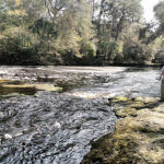
- Scenic Dallus Creek, one of many unique waterways highlighted along the Big Bend route. Photo courtesy of Jan Wells, Oct. 2017.
-
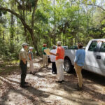
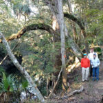
- FTA Board Members tour an FWC parcel along the reroute with our land management partners.
-
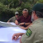
- Agency staff review maps of the proposed reroute.
-
- Steinhatchee Falls, a rare Florida waterfall located along the new Florida Trail route. Photo courtesy of Jan Wells, Oct. 2017.
-
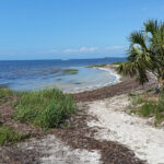
- The Big Bend reroute highlights the unique wetlands along Florida’s Gulf Coast, seen here at Keaton Beach. Photo source: Nature Coast Adventurer
-
- FTA Board Members hike along the Aucilla Sinks section. The Aucilla Section will remain an official designated spur trail of the Florida National Scenic Trail. Photo courtesy of Leslie Wheeler, Oct. 2017.
-
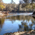
- Hikers will be able to access the Suwannee River Wilderness Trail from the Big Bend route at Lafayette Blue Springs State Park. Photo courtesy of Jan Wells, Oct. 2017.
-
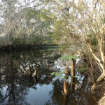
- Hikers will cross the remote Fenholloway River midway along the Big Bend route.