Welcome to the PNTS Map Portal
Explore the National Trails System with interactive maps showcasing the approximate routes for the 11 National Scenic Trails and 19 National Historic Trails in the National Trails System, as well as a downloadable PDF map created by the National Park Service.
These maps are for reference and should not be used to plan hikes or other visits to the National Trail System. You can find resources to help plan hikes and answers to your trail-specific questions by contacting the nonprofit organization and/or Federal agency responsible for maintaining that trail. Learn more about each National Scenic and Historic Trails and find the organization or agency that maintains to the trail for resources here.
If you’re interested in learning more about other trail routes, click here for an interactive map of National Recreation Trails, or look for other local trails near you on State or local government websites.
Explore, enjoy, and, if you have any questions, email us at admin@pnts.org.
National Scenic & Historic Trails Interactive Map
 This interactive map was created in the spring of 2021 through a project led by the Partnership for the National Trails System (PNTS) in collaboration with the Trust for Public Land (TPL). Use this interactive map to track the course of all 30 National Scenic and Historic Trails from above in 2D and 3D at 1:100,000 scale.
Explore the topography of the land traversed by the trails that interest you or discover new trails you didn’t even know existed. This map will even allow you to overlay the NTS routes on street maps, satellite images, and more. The customization options make this map a great tool to use for research, school projects, and presentations.
Special thanks to the Federal Highway Administration for providing the funding needed to complete and maintain this resource, to TPL for their technological support, and to PNTS member organizations, the National Park Service, the U.S. Forest Service and the Bureau of Land Management for their support of the project.
National Park Service National Trails System Webmap
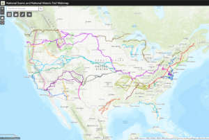 This interactive, color-coded map makes it easy for users to explore the 30 National Scenic and Historic Trails that make up the National Trails System.
Use the “Draw” mode to add pins and icons to points of interest, measure distances and acreage with the “Measurement” feature, and zoom in close to see where trails intersect with public lands and pass through gateway communities.
Special thanks to Matt Robinson and Peter Bonsall of the National Park Service for developing this valuable resource.
National Park Service National Trail System Map PDF

Updated in 2018 for the 50th Anniversary of the passage of the 1968 National Trail System Act that laid the groundwork for the National Trail System as we know it today, this PDF map features the routes of all 30 National Scenic and Historic Trails, the logo for each trail, and a color code for each type of public land the trails traverse.
Download it as a screensaver or background, print it out to share with friend or hang on your wall, or include it in your next presentation or project about the National Trails System.
![]()
Ready to explore more trails? Click here to find a National Recreation Trail near you.
Support the National Trails System
As you view these maps, you may notice some gaps in trails. This is because the National Trails System is still a work in progress. In fact, there are still nearly 20,000 miles of the 55,000+ miles of Congressionally designated National Scenic and Historic Trails to be built or conserved.
PNTS is a connector, collective voice and resource for the nonprofit organizations and Federal agencies that co-manage the 30 National Scenic and Historic Trails. We advocate for a vibrant, connected National Trails System for all. From the halls fo Congress to webinars and trainings that educate people about voluntary land conservation, we work to help our members and partners complete trails and conserve critical viewsheds and side trails for habitat conservation, climate resilience and greater accessibility from towns and cities.
Show your support for the Partnership for the National Trails System and help us continue this work by making a donation. The National Trails System and its tens of millions of annual visitors thank you for your support,