Author: Ryan Cooper
National Park Service staff recently completed a project in collaboration with 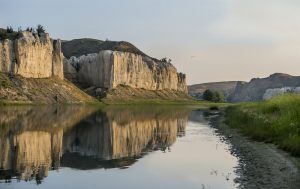 The Wilderness Society using GIS to analyze the composition of land cover and status of vegetation condition and identify conservation protections along the 3,700 mile Lewis and Clark National Historic Trail. The trail commemorates the 1804-1806 expedition of Lewis and Clark and the Corps of Discovery, an epic journey of exploration of the Louisiana Purchase and beyond. During their 1804-1806 expedition, Lewis and Clark and the Corps of Discovery explored and mapped a large portion of the North American continent that had seen limited Euro-American influence and recorded a vast amount of information about the landscapes and resources they encountered. These historic observations and descriptions provide us with a connection to the past and highlight the changes that have taken place in the years since the expedition. Much Trail research has focused on the history of the expedition and has provided qualitative evaluations that vaguely refer to dramatic landscape changes throughout vast portions of the Trail over the last two centuries. Little has been done to quantitatively evaluate ecological conditions or assess land management areas of the contemporary landscape along the Trail.
Ryan M. Cooper and Rachel Daniels of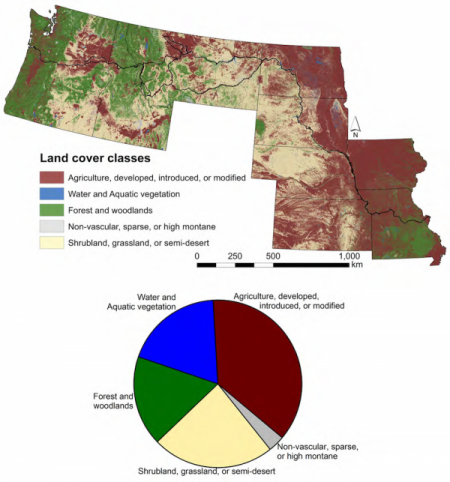 the National Park Service along with Dr. Travis Belote of TheWilderness Society used spatial data to analyze land cover and vegetation composition, examine conservation status, and identify the wildest remaining areas along a buffered area extending 1 mile on either side of the Trail. Datasets used in the study include the historic route of the Lewis and Clark expedition, the GAP Analysis Program protected areas database, GAP land cover data, the US Forest Service inventoried “roadless” areas, national wilderness areas, an index of “wildness” in the lower 48 states, and the current distribution of grizzly bear habitat. The layers were combined using ArcGIS Spatial Analyst, allowing each of the resulting datasets to be queried individually or together. The results show that while much of the Trail has been altered through agricultural development and land use in the past 210 years, small areas remain relatively wild and offer visitors the opportunity to experience a landscape with some degree of historical fidelity. The majority of the Trail passes through lands with no known conservation protections and wilderness areas and national parks comprise very little of the area. However, two significant spots in the Northern Rockies — the mountains west of Lolo Pass and the upper Blackfoot River watershed — were identified where the Trail passes through “roadless” areas of federally administered lands and where legislative protections could keep remaining wild lands intact and preserved for future generations. The study and results were published in the January, 2017 issue of Natural Areas Journal 37(1). For more information, please contact Ryan_M_Cooper@nps.gov.