Trails are Indigenous. Trails flow and live through the territories and are guides for many histories, people, animals and entities living and nonliving. We acknowledge that this project aims to strengthen relations for National Trails and Indigenous communities throughout Indigenous Territories and what is now considered United States.
Historically, cartography and maps have been used as an instrument of colonization which has been severely detrimental to the adequate representation of Indigenous peoples. Indigenous peoples and communities were often left out of the conversation.
In January 2022, the Partnership for the National Trails System (PNTS) launched the Native Lands, National Trails (NLNT) project to provide space for Indigenous voices. In collaboration with the Bureau of Land Management, Native Land Digital (NLD) and Ancestral Lands Conservation Corps Indigenous nations, communities and organizations are being invited into the conversation to help steward, provide Indigenous ways of knowing, and the histories/stories that have been excluded previously on public lands. This project is collaborative and does not aim to define Indigenous communities but instead provide an inclusive mapping and resource platform that includes all Alaska Native, Native Hawaiian, recognized and non-recognized tribes.
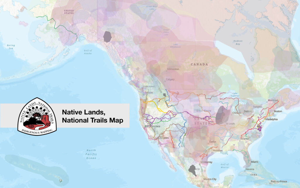
Native Lands, National Trails consists of an interactive GIS map and resource kit that will serve as a cultural awareness tool that shows the intersection and relationship between Indigenous lands and the National Trail System “in a manner that respects Tribal sovereignty and achieves mutually beneficial outcomes for Tribal and Indigenous communities.”* The interactive GIS map is hosted through ESRI, to make it accessible to the public, federal agencies, trail organizations, tribal nations and/or Indigenous communities.
The map overlays an Indigenous Territories layer from NLD onto the National Trail System map and showcases the Indigenous communities that have inhabited these lands over time. The NLD data is a work in progress that relies on contributions from the community to create inclusive and accurate information. As this dataset is continuously being updated, the map will never be perfect. Suggestions for improvement can be made via NLD at info@native-land.ca.
It is crucial to understand that borders and boundaries have been fluid when it comes to describing territory or landscapes within Indigenous communities. This differs from Native Federal land (reservation and trust land) as these boundaries are considered to be political. The Nation-to-Nation relationship between the United States and Tribal Nations is governed by law and differs from the public engagement and collaboration with Indigenous communities that is offered here. Our map does not represent any official or legal territory boundaries, reservations, trust lands, etc. Please contact tribal governments and proper agencies for this data.
Native Lands, National Trails logo artist Autry Lomahongva and project coordinator Kiana Estate-Gashytewa.
The 30 National Scenic and Historic Trails (NSHT) on the map are representations of the Congressionally designated trail routes and should not be used for navigation purposes or detailed planning. Consult administering agencies for up to date information.
The resource kit/hub features examples of Indigenous collaboration on NSHT’s, information from Indigenous organizations and information pertinent resources for using the NLNT map. These educational resources should be used in conjunction with PNTS’ Tribal Consultation webinar series which is available to watch online.
We encourage you to play around with the features on the map, explore the resources in the toolkit, and learn more about the ancestral territories you reside on or recreate through! We hope this project will contribute to the ongoing efforts to advance National Trails System knowledge of Indigenous ancestral lands and increase partnerships and collaborations with Indigenous communities and nations along trails.
*From the “Guidance for Federal Departments and Agencies on Indigenous Knowledge” November 30th 2022
Native Lands, National Trails Resources
- NLNT Resource Toolkit
- NLNT Interactive GIS Map
- Project Overview Video
- Tribal Consultation Webinar Series
- Engagement and Education with the Indigenous Mapping and Research Project Webinar
Project Partners
