By: Peter Bonsall, Geographer – GIS Specialist, and Matt Robinson, GIS Specialist, National Park Service and Appalachian National Scenic Trail, respectively
A Geographic Information System (GIS) is a powerful tool that allows users to view a variety of geographic data, perform spatial analysis, and conduct locational based research in both a desktop and online environment. Over the past year, the National Trails System (NTS) has made tremendous strides in utilizing this technology to enhance its capabilities at a national, system-wide scale. With the development of the National Trails System Webmapping Application, users now have the ability to view, download, and analyze authoritative centerline data for all 30 national scenic and historic trails.
PREVIOUS CHALLENGES
This is a particularly notable achievement since GIS capabilities across the NTS vary from trail to trail. Some national scenic and historic trails have in-house GIS capacity and are able to provide the public with accurate mapping information, while others do not have any GIS capacity and have traditionally relied upon dated cartographic products as their public resource. Ownership of NTS GIS data is also scattered across Federal agencies and nongovernmental partner groups, with some data being managed by the National Park Service, some by the U.S. Forest Service, and some by nongovernmental organizations. This creates quite a challenge when trying to consolidate data or perform spatial analysis at a national level. And, until recently, to locate national trail GIS data a user would have to contact each national trail individually to acquire centerline data, a process that is both difficult and time consuming. With the NTS Webmapping Application, that has all changed.
CENTERLINE DATA
The goal of the NTS Webmapping Application is to provide the public with a centralized location to view and download authoritative GIS data for all 30 national scenic and historic trails. It is built using the Environmental Systems Research Institute’s (ESRI) ArcGIS Online technology, which allows each national trail dataset to be maintained and updated by its respective trail GIS steward, but consolidated and shown in one location within the NTS Webmapping Application. This ensures that when each GIS steward updates its data, the webmapping application remains accurate and shows the latest authoritative data for each trail. Currently, the primary focus is on centerline data for each trail, but the hope is that additional trail data will be added to the application in the future such as campgrounds, trailheads, etc.
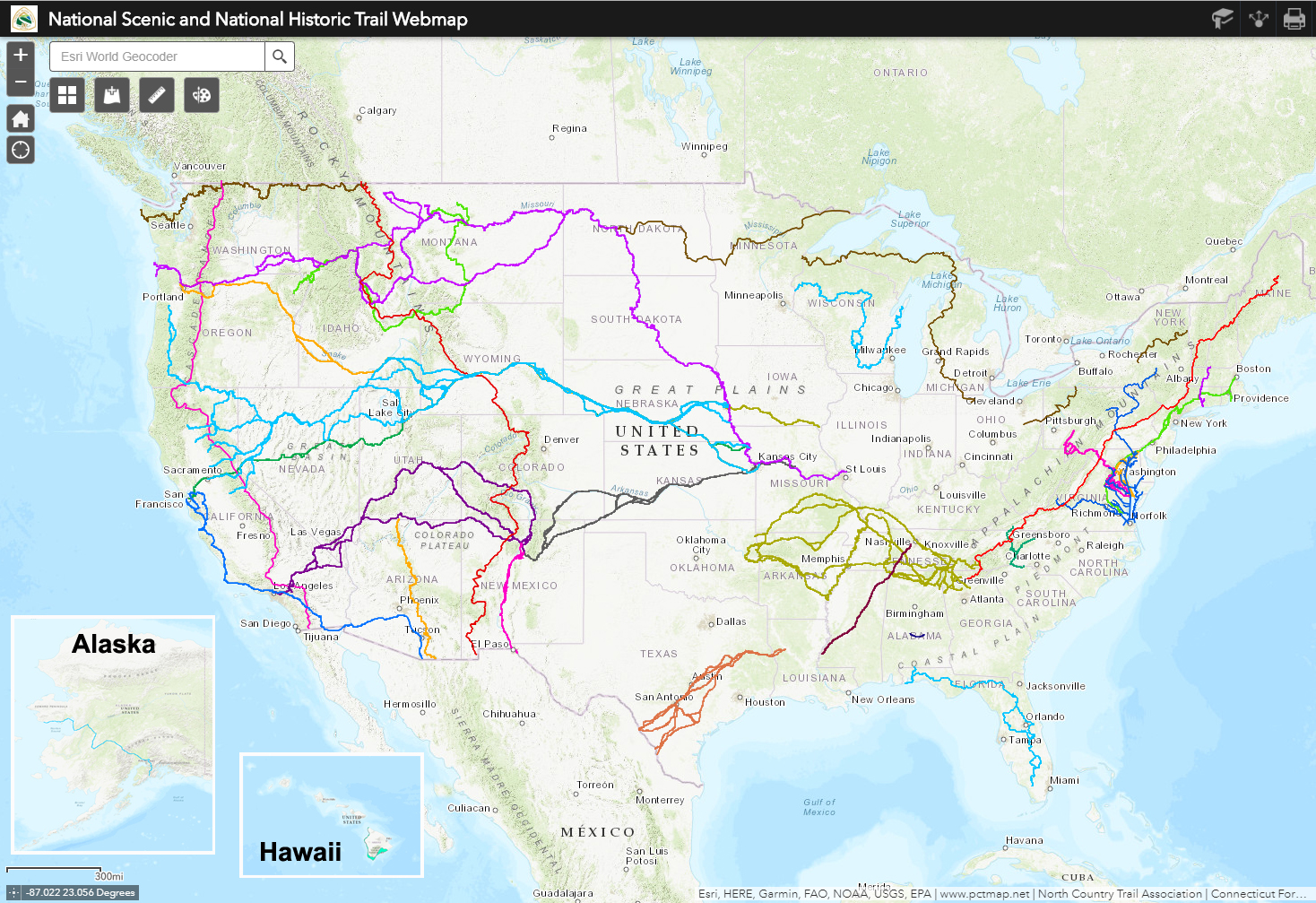
Screenshot of the National Trails System Webmapping Application displaying centerline data for all 30 National Scenic and National Historic Trails.
INTERACTIVE LAYERS
Simply being able to see the whole NTS overlaid on one map is an astounding way to see the extent of the system, but the NTS Webmapping Application offers much more than that. With it, users can zoom in and interactively explore each trail, they can turn on and off individual layers, and they can access additional information and links to official web pages by clicking on any trail. Users can also download individual trail centerline data, allowing for more focused and locally based analyses to be conducted.
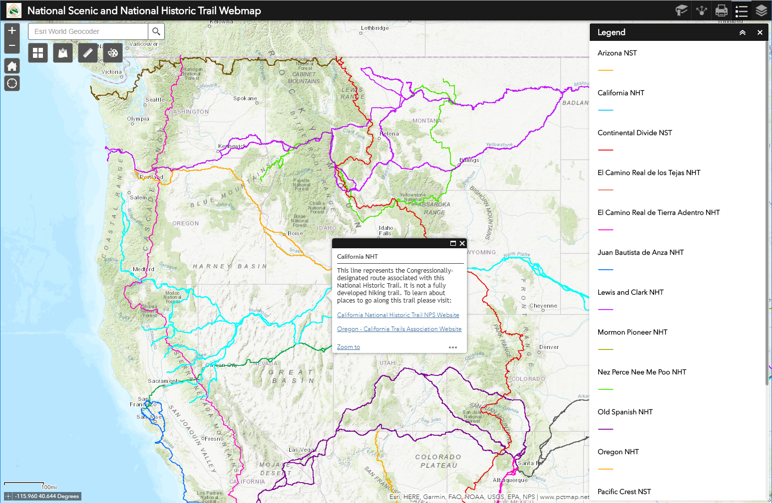
Screenshot of an attribute pop-up window, allowing users to view more information about a trail and access official trail websites. Currently highlighted is the California National Historic Trail.
ADDITIONAL DATA
The NTS Webmapping Application also allows users to view national recreation trail point data, which is a subset of the NTS that focuses on local, short distance trails, as well as view the Protected Areas Database of the United States (PADUS), which displays the boundaries of protected areas across the country. Additionally, users can toggle on and off a variety of base layers, draw upon data from across the ArcGIS Online environment, and add their own personally hosted data using the “Add Data” tool within the webmapping application.
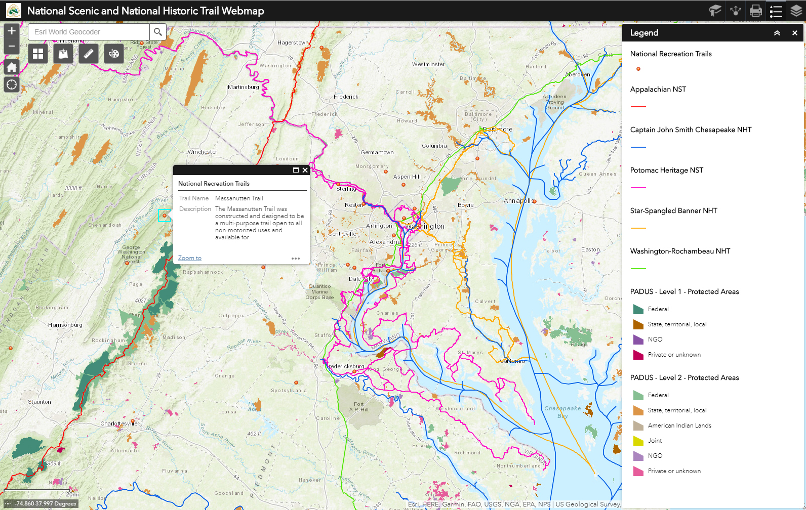
Screenshot of the National Trails System Webmapping Application showing additional National Recreation Trail and Protected Areas Database of the United States (PADUS) layers.
STORY MAPS
The NTS Webmapping Application is a great promotional and interpretive tool that can be viewed either as a standalone application or embedded within a webpage or other online media, such as a Story Map. Story Maps are online applications that utilize geographic data along with photos and text to tell a story, and many Federal agencies, including the National Park Service, U.S. Fish and Wildlife Service, and the Bureau of Land Management, are using them to spatially and descriptively highlight interpretive elements across the National Trails System. One example of this is the National Trails System Story Map (www.trails50.org/story-map), created for the 50th anniversary of the passing of the National Trails System Act. See more examples here: www.pnts.org/new/blm-fws-nps-launch-story-maps/.

The National Trails System Story Map was created with the NTS Webmapping Application for the 50th anniversary of the National Trails System Act at www.trails50.org/story-map. Users can view information and photos about each national scenic and historic trail, as well as locate the trail on the webmap.
PARTNER ENGAGEMENT
Another example of how the NTS Webmapping Application is being used comes from the National Park Service National Trails Intermountain Region (NTIR), which manages nine of the national historic trails. The NTIR has used the webmapping application as an outlet for engaging partners associated with their national historic trails. Presentations utilizing the webmapping application have been shared at the Tribal GIS Conference in Albuquerque, NM, and at board meetings with the Oregon-California Trails Association and the El Camino Real de los Tejas NHT Association, which have made it easier for partners to view and analyze their respective national historic trail.
The NTS Webmapping Application is a foundation of success in the National Trails System. With public, authoritative data now available in one location, anyone from interagency staff to partner organizations to local trail enthusiasts can access this information, learn about national trails, and download data. The foundation is set, and now it is time to build upon it.
Share Your Trail’s Experience
The Partnership for the National Trails System is curious how you are using the National Trails System Webmapping Application and what you would like to see added in the future. Please contact Samantha Haas, PNTS Communications Coordinator, with any examples or ideas, which might be shared in future articles: communication@pnts.org
View the National Trails System Webmapping Application: www.pnts.org/new/map-interactive-gis/
Unless otherwise indicated, all material in Pathways Across America is public domain. All views expressed herein are perspectives of individuals working on behalf of the National Trails System and do not necessarily represent the viewpoint of the Federal agencies.