by Gary Werner, Executive Director, Partnership for the National Trails System
Congress’s intent in establishing the National Trails System was for national scenic trails to be continuous off-road pathways and for both the national scenic and national historic trails to preserve the natural, cultural, historic, and scenic resources along them. This lofty and ambitious intent has only been spottily and inconsistently accomplished in the 50 year history of the National Trails System.
A monumental effort by the National Park Service and the U.S. Forest Service between 1978 and 2005 conserved several hundred thousand acres of land to provide a continuous protected corridor for the Appalachian National Scenic Trail. A similar, but smaller-scale, effort by the U.S. Forest Service closed many of the gaps in the Pacific Crest National Scenic Trail during that same time period. During this time, the Bureau of Land Management (BLM) acquired a number of parcels along the Sandy River in Oregon to benefit the Oregon National Historic Trail.
Another surge of gap-closing and resource preservation funded by Congress through the Land and Water Conservation Fund occurred along the Florida and Ice Age National Scenic Trails through the first decade of the 21st Century. However, land acquisition to extend the rest of the national scenic and historic trails and preserve their resources has been a rare occurrence.
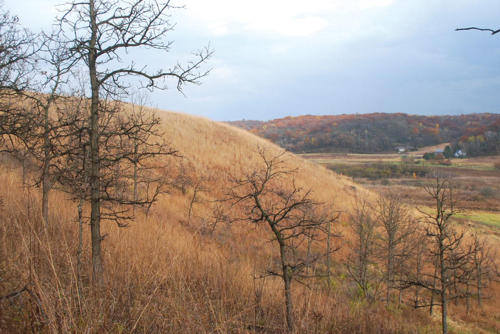
Melanie Lord collects sideoats grama grass seeds near the Lodi Marsh Segment of the Ice Age National Scenic Trail in Lodi, WI.
Collaborative Landscape Planning Projects
The Collaborative Landscape Planning initiative of the second half of the Obama administration provided a major new approach and surge in land and resource conservation for the National Trails System. For the first time, from 2015 through 2018, the four Federal land managing agencies treated the National Trails System as a whole, and as one of several large landscapes in which to focus their land and resource conservation work. During each of those years, the Partnership for the National Trails System compiled packages of 50-60 land conservation projects along 12-15 of the national scenic and historic trails and presented them to the agencies to support. With that support, Congress appropriated more than $77 million of Land and Water Conservation Fund money during those years to acquire 45 critically important segments of national scenic and historic trails. One example includes BLM’s acquisition of the Alamocita Creek parcel in New Mexico, which allows 55 miles of Continental Divide National Scenic Trail to be removed from roads, accomplished in concert with the private landowners, the USFS, and the Rocky Mountain Elk Foundation.
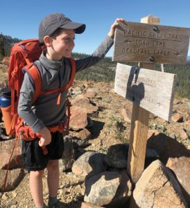
A youth hiker pauses at the intersection of the Pacific Crest National Scenic Trail and the Sisson-Callahan Trail. The Trinity Divide acquisition will allow for the U.S. Forest Service to develop new loop hikes incorporating the PCT and providing better access to these public lands. (Photo Credit: Megan Wargo, PCTA)
In this issue of Pathways Across America, we are celebrating the recent completion of two of these Collaborative Landscape Planning projects. In June, The Conservation Fund and the U.S. Fish and Wildlife Service completed conservation of 252 acres atop Fones Cliffs along the Rappahannock River in Virginia. This site is critically important to the Rappahannock Tribe, the Rappahannock River National Wildlife Refuge, and to the Captain John Smith Chesapeake National Historic Trail. Read more here.
Later this summer, the Pacific Crest Trail Association and the U.S. Forest Service (USFS) completed a multi-year effort to protect 17 miles of the Pacific Crest National Scenic Trail along the Trinity Divide in northern California. This involved one of the largest land purchases—10,300 acres—made to protect the integrity and scenic quality of the Trail.
While we celebrate and salute these wonderful accomplishments and encourage other trail conservation work currently underway along the Ala Kahakai, Ice Age, Oregon, Overmountain Victory, and Santa Fe trails, we also recognize that disruptive threats to the integrity of all the national scenic and historic trails are increasing and require that we devise ways to significantly increase the progress of permanent protection of trail resources throughout the National Trails System. To that end and toward fulfillment of our Decade Goal Number 2—To Complete and Protect the National Scenic and Historic Trails on the Ground—set in 2008, we happily share updates on two important projects now underway within the Partnership for the National Trails System.
Gap Analysis Progress
The first of these projects is preparing a Gap Analysis of all 30 national scenic and historic trails. We introduced this project in the Summer Pathways, and now close to nine months into the project we are able to provide an accounting of the work done to date. This project, funded by the Federal Highway Administration, involves a significant new collaboration with The Trust for Public Land, bringing their sophisticated mapping capabilities to bear to map the national scenic and historic trails in ways not yet done.
PNTS consultant Don Owen, who has more than 30 years of experience in conserving and managing lands and easements with the National Park Service, the Land Trust of Virginia, and the Land Trust Alliance, is managing this project. He reports on it here.
Another component of this project involves researching, collecting, and sharing the various kinds of legal agreements being used to protect land and resources within the National Trails System. We will also prepare a series of case studies describing how successful trail land preservation projects have been done. The first of these case studies, about the recently completed Trinity Divide project on the Pacific Crest National Scenic Trail, is available to view and download from our website at www.pnts.org/new/our-work/reports or directly here.
While the Gap Analysis will provide useful information to help us guide conservation of land and resources along all 30 national scenic and historic trails, it will add an important dimension to our understanding of the collective resources of the national historic trails.
We already have a good estimate of the length of the gaps along the nine national scenic trails authorized after 1968. The Gap Analysis will refine the location and length of these gaps and provide information to help analyze the threats to them and how to prioritize which ones to try to close first. But the Gap Analysis also will be the first time that a comprehensive list of the “High Potential Sites” and “High Potential Route Segments” along the 19 national historic trails will be compiled and analyzed in a similar manner. This information should help us to prioritize how to focus resources to conserve these essential components of the historic trails.
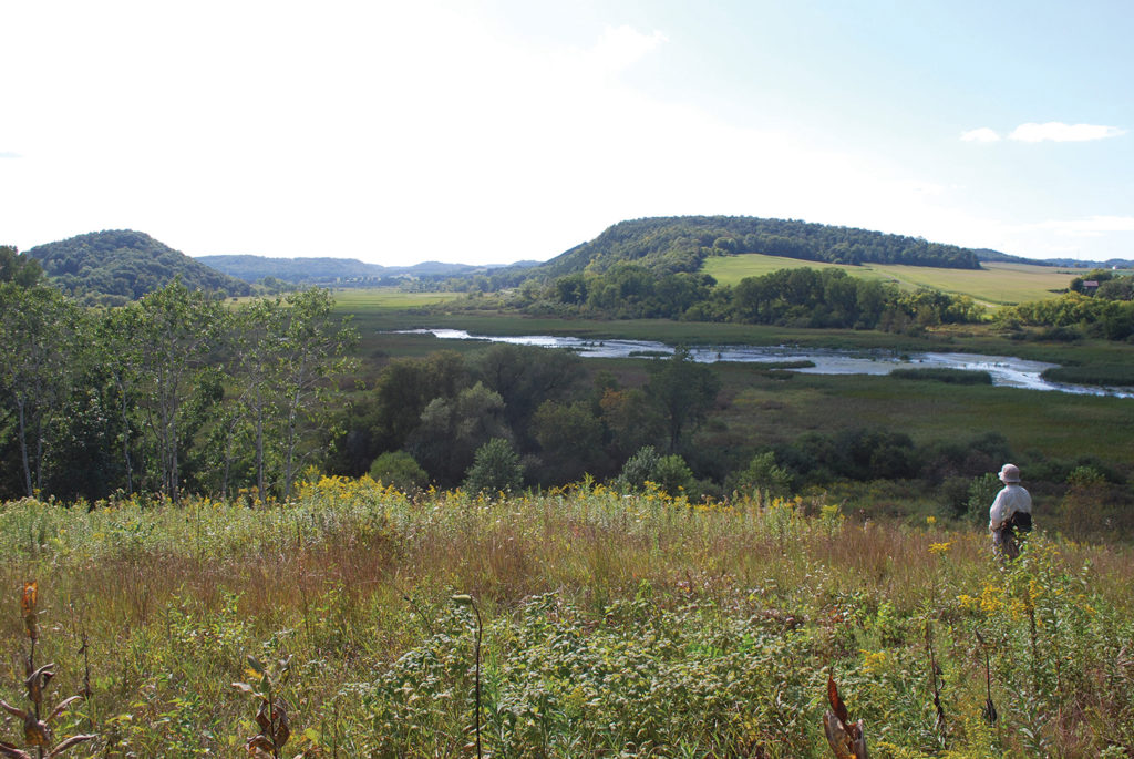
The Table Bluff Segment of the Ice Age National Scenic Trail near Cross Plains, WI features short grass prairie and oak savanna. (Photo Credit: Gary Werner)
National Trails Action Plan
The second of the projects now underway is working on devising a strategy to revive the magnitude of funding support provided by Congress during the Collaborative Landscape Planning years of the Obama Administration. Retired Appalachian Trail Conservancy Executive Director Ron Tipton is leading a team of strategists to devise a five year Action Plan to greatly increase the resources for both operating all 30 national scenic and historic trails and acquiring the land to close their gaps and preserve their critical resources.
While significantly increasing support for the national trails by Congress and the Federal agencies is a major focus of this effort, strategizing is not confined to the Federal arena alone. Mobilizing ways to greatly increase the support of State and local governments and attracting private sector funding to aid this work to appropriately fund the national trails are also major components of this project. Although the initial planning time frame is five years, the strategies within this National Trails System Action Plan could propel a new era of consistent year-by-year conservation of land and resources along national scenic and historic trails for many years to come. The intent is to have a draft Action Plan ready to present to the leaders of the Partnership for the National Trails System before the end of this year. Learn more about this plan here.
We are poised on a threshold to embark on the joyful and fulfilling work of consistently conserving lands, resources, and the quality of the experiences provided by our national scenic and historic trails—all the while strengthening our connections to our good Earth. Won’t you help us cross that threshold?
Happy Autumn enjoying the beauty of our trails and the lands through which they lead us!
Gary Werner
Unless otherwise indicated, all material in Pathways Across America is public domain. All views expressed herein are perspectives of individuals working on behalf of the National Trails System and do not necessarily represent the viewpoint of the Federal agencies.