by Don Owen, Consultant, Partnership for the National Trails System
Fifty years after the passage of the National Trails System Act, many critically important landscapes and resources of the National Trails System lack any permanent protection.
Thanks to a cooperative agreement with the Federal Highway Administration, the Partnership for the National Trails System (PNTS), in collaboration with the Trust for Public Land (TPL), is developing an integrated Geographic Information System (GIS) approach to identify and prioritize trail protection projects throughout the National Trails System.
This effort dovetails with the recently developed interactive Webmapping Application of the National Trails System, which utilizes the ArcGIS Online platform to create a single online map for all 30 national scenic and historic trails and their publicly available data.
PNTS and TPL are currently refining the methodology for the project, using two national scenic trails (the Ice Age and North Country) and two national historic trails (the Santa Fe and Lewis and Clark).
PNTS also will identify, analyze, and catalogue model agreements and develop case studies of conservation easements and other techniques for protecting national trails. At the completion of the project, this information will be organized into a draft Handbook for National Trails Protection.
The Gap Analysis project will be done in close cooperation with trail partners. PNTS will be reaching out to trail organizations and agency partners in the coming months.
Elements of the Gap Analysis
- Collecting, evaluating, and aggregating existing trail data into a single GIS database;
- Identifying and analyzing data sets to obtain the best available data;
- Analyzing trail areas on public land or in protected areas using the United States Geological Survey Protected Areas Database (PAD-US), the National Conservation Easement Database (NCED), and other publicly available data sets;
- Analyzing unprotected national trail segments and resources using development risk modeling;
- Developing a GIS database that depicts national trail segments by protected/unprotected status and quantifies protected status and threats to trails by jurisdiction; and
- Developing a web map viewer that provides national trail managers with the ability to view trail corridor protection status for any segment of a national trail.
View the National Trails System Webmapping Application: www.pnts.org/new/map-interactive-gis/
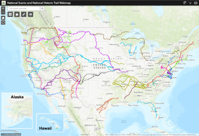
Screenshot of the National Trails System Webmapping Application displaying centerline data for all 30 National Scenic and National Historic Trails.
Unless otherwise indicated, all material in Pathways Across America is public domain. All views expressed herein are perspectives of individuals working on behalf of the National Trails System and do not necessarily represent the viewpoint of the Federal agencies.