The Arizona Trail Association provided the following highlights for the Arizona NST during the 2021 calendar year:
Conserving Trail Lands and Boosting Climate Resilience
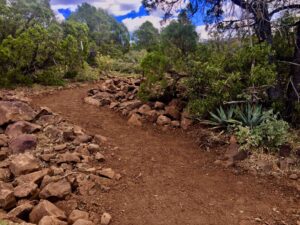
The Arizona Trail Association successfully completed the Alder Ridge Reroute, replacing 9 miles of a road walk along a powerline road with new trail construction on the Tonto National Forest. ATA Photo
Staff, volunteers and Federal agency employees worked together to restore a natural spring that was negatively impacted by a recent wildfire and post-fire erosion. The Arizona Trail Association (ATA) refurbished Pigeon Spring in the Four Peaks region of the Tonto National Forest, which will increase water reliability for thru-hikers in an otherwise arid area. The project also offers “immense benefits for wildlife,” according to ATA Executive Director Matt Nelson.
The ATA also added a new section of trail to create an alternate route that provides a more hiker-friendly experience. The Alder Ridge re-route replaced a former 9-mile walk along a Forest Service road marred with powerlines and often used by ATVs with 7 miles of singletrack trail near Pine, Arizona. It took the Arizona Trail Association 6 months, a $105,000 grant from the Recreational Trails Program administered by Arizona State Parks and Trails, and hundreds of volunteer hours to complete. The hard work resulted in a clear path through the Mazatzal Wilderness.
Collaboration and Engagement
Strengthening Organizations and Partnerships
Local Economy, Tourism and Community Health
ATA worked in partnership with the Arizona Office of Tourism to print 10,000 maps of the Arizona Trail (with itineraries) and a statewide distribution plan to help promote the trail and gateway communities.